Multipitch Atlas

Vendredi 13

Contreforts du Grand Bec (upper part) · Vanoise (Grand Bec) · France

Easy to bailBolting confidence: high

A short, sunny high-mountain route at 2800 m in the Vanoise: five 25 to 30 m pitches of 4b to 5b with one or two moves of 5c that can be pulled through, then an easy scramble. The bolting is generous enough that parties with little experience enjoy it. The setting, below the south-west face of the Grand Bec, is the reason to walk up.

Photo-topo of Vendredi 13 on the upper Contreforts du Grand Bec, with belays R1 to R5Photo: cassien vanoise · CC BY-SA 3.0

Topo

Photo-topo of Vendredi 13 on the upper Contreforts du Grand Bec, with belays R1 to R5Photo: cassien vanoise · CC BY-SA 3.0
Hardest pitch
5c
Pitches
6
Length
180 m
Approach
135 min
Aspect
S
South-facing
Rope
1×50 m

The route

Overview

Vendredi 13 lies at the highest point of the Contreforts du Grand Bec, just before the cliff meets the south-west face of the Grand Bec itself. It was opened in 2015 and 2016 by the two local climbers who equipped most of this sector. The hardest climbing is at the start of the second pitch, one or two moves of 5c followed by 5b, and the bolts there are close enough to pull on; the rest is 4b to 5a with one harder move of 5b on the fifth pitch. A sixth, easy pitch leads to the top of the buttress, from where you can abseil back down or walk on towards the west ridge of the Grand Bec. It can be done in a day from the road without using the hut.

The climbing

Pitch by pitch

Pitches of Vendredi 13
PitchGradeLengthBoltsNotes
P15a25 m9 bolts4c with one move of 5a. Early in the season the bottom of the pitch can be partly under snow. A 2018 party found the last bolt broken, which did not matter.
P25c30 m14 boltsOne or two moves of 5c at the start, then 5b; the bolts allow you to pull through everything. An intermediate belay, not linked, lets you split the pitch. The belay at the top was the only unlinked one in 2018.
P34b25 m6 boltsEasier pitch.
P45a25 m7 bolts5a.
P55b25 m7 bolts5a with one harder move of 5b.
P63b50 m3 boltsEasy scrambling to the top of the buttress; the bolt count is given with a question mark on camptocamp.

Getting there

Approach

To the parking

From Moûtiers drive towards Pralognan-la-Vanoise. After the village of Le Planay take the small road on the left towards Chambéranger and continue to Plan Fournier (about 1700 m), where there is a small car park; the road is narrow and steep. A forest track continues to a higher parking place at about 1850 m, but a 2021 party found it badly damaged. Walk to the Refuge du Grand Bec (2403 m): camptocamp gives 2 h 15 and 680 m of ascent, and fit parties take about 1 h 20.

On foot · about 135 min

From the hut head towards the Vuzelle glacier on the path that passes the old hut. After the flat area follow cairns and the line of the stream up a steep moraine; the last 50 m to the foot of the route are awkward scree, or a snow cone early in the season. The start is at the highest point of the buttresses, with a fault line running parallel to the route and, early in the season, a waterfall to its right. There is no name at the base, only a piece of cord marking the start. Allow about 1 hour from the hut.

Map of the walk-in

  • Crag
  • Parking

Loading map

The point marks the crag, not the exact start of the route.

Coordinates · crag

45.42043, 6.74353

Parking

45.42761, 6.71656

Chambéranger / Plan Fournier access point (camptocamp waypoint 104249)

Point from camptocamp waypoint 542448 (Contreforts du Grand Bec)

For your phone or watch

Download GPX

Contains the route point and parking. Opens in most mapping apps and GPS watches.

Points are compiled from published sources, with the precision stated above. They were not surveyed on the ground: check them against a current topo.

Getting down

Descent

Either abseil the route from the fifth belay, down-climbing the easy sixth pitch first: the stations have maillons and a 2018 party took 1 hour for the abseils. Or continue on foot: easy ground leads in about 15 minutes to the approach route of the Grand Bec west ridge, which you follow back down to the hut.

Retreat

Bailing off the route

Easy to bail

Abseiling the route is a described descent, with maillons in place at the belays. Parties have retreated this way from the third belay (2018, in stonefall) and from the fifth (2022). Pitches are 25 to 30 m, so a single 50 m rope works.

Retreat from
Any belay up to the fifth; the sixth pitch is down-climbed.
Point of no return
None.
Carry
A 50 m rope. The second belay and the intermediate stance on pitch 2 were not linked in 2018, so carry a sling and a maillon.
Basis
Stated in the sourcesCamptocamp describes the abseil descent; two trip reports describe retreats.

Safety

Hazards

  • Stonefall: on a hot day in September 2018 a party was driven off from the third belay by repeated volleys of rock, one block narrowly missing them on the last abseil. They suspected a melting snow patch above. No later report mentions it, but wear a helmet and be wary in hot weather or early in the season.
  • Snow at the foot of the route and a wet first pitch early in the season.
  • A high, remote setting more than two hours from the road; afternoon storms build quickly on the Grand Bec.
  • The start is unmarked apart from a cord, and parties have lost time finding it.

Sun and weather

Conditions

South-facing at about 2750 to 2900 m. Despite the aspect, a late-August 2022 party had no sun on the start before 11:00 and found it cold. Snow lies at the base into July (a 10 m snow patch in early July 2023). Trip reports run from early July to late October. The hut is wardened from mid-June to mid-September and has an open winter room outside that period.

Usual season · Jul to Sep

Sun on the wall · S-facing

Working out the sunlit hours for this month.

  • January: not yet worked out
  • February: not yet worked out
  • March: not yet worked out
  • April: not yet worked out
  • May: not yet worked out
  • June: not yet worked out
  • July (usual season): not yet worked out
  • August (usual season): not yet worked out
  • September (usual season): not yet worked out
  • October: not yet worked out
  • November: not yet worked out
  • December: not yet worked out

Sun on the wallDaylight, wall in shade● Usual season

Estimated from the wall's aspect only. Ignores surrounding terrain, gullies and the wall's exact shape. Clock times are local to the wall (Central European time), for the 15th of each month.

Climate figures for Vanoise (Grand Bec) are not available yet

What to carry

Gear

12 to 15 quickdraws, a single 50 m rope and a helmet. No cams or nuts.

Checklist

Quickdraws
14
Rope
1×50 m
Helmet
One each
Abseil device and prusik
The descent or the retreat involves abseiling
Slings
Mentioned for retreat
Maillons or spare karabiners
To leave behind if you retreat

Derived from the route data; check it against a current topo

From climbers

Reader reports

Reader reports are not being collected yet. Until they are, check a current topo and the local club or guidebook publisher for recent changes to Vendredi 13.

Worth knowing

Tips

  • Allow about 3 hours for the route and 4 hours hut to hut.
  • It links naturally with the Voie Cassien on the south face of the Grand Bec: follow cairns for 15 minutes from the top. That is a much longer and more serious outing.
  • A 2026 party recommends it as an afternoon route or a warm-up for the harder routes on the buttresses.

Open questions

Where sources disagree

  • Length: camptocamp's header gives 120 m of difficulties, while its pitch list adds up to 180 m including the 50 m easy last pitch; the crag page says the routes are 90 to 120 m high.
  • Pitch 5 or 6: a 2018 party places the 5b move on 'L6', counting the intermediate belay on pitch 2 as a separate pitch.
  • Approach: about 1 hour from the hut in a 2026 report; the route page gives no time.

Provenance

Sources

Around 5c · about 6 pitches

Similar elsewhere

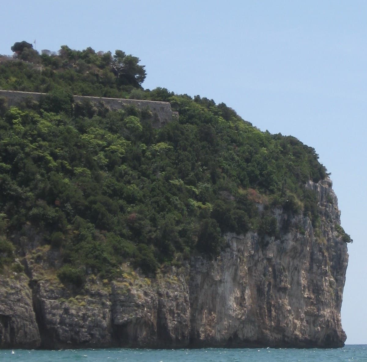
The sea cliff of Montagna Spaccata seen from the beach at Gaeta

Italy · Gaeta & Sperlonga

Via dello Spigolo

This was the second route on Montagna Spaccata and is the cliff's classic moderate. It's never hard but never trivial, with continuous exposure above the sea: a horizontal crack traverse, an athletic juggy chimney and corners. Gulliver gives UIAA grades V–V+ / IV+–V / V+ / V / V–IV+ (5c max), converted here.

5c5 pitches125 m

Read the cautionsCommitting
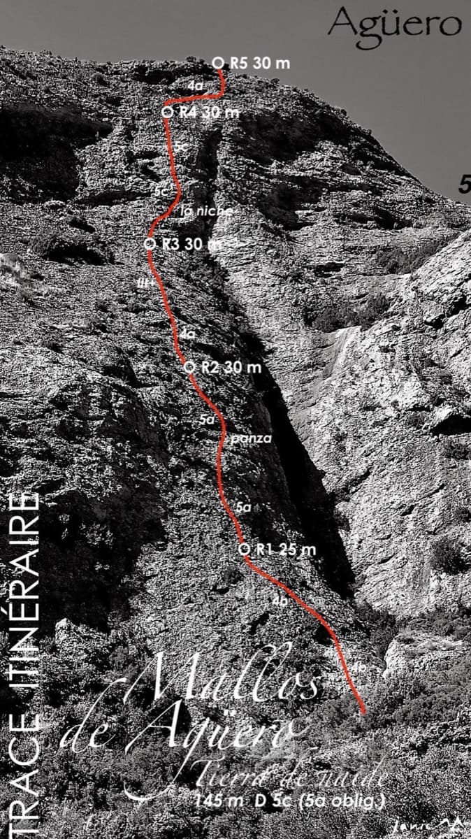
Topo of Tierra de Naide, Mallos de Agüero

Spain · Riglos & Agüero (Mallos)

Tierra de Naide

A morning-sun route at the quieter Agüero mallos. Easy slabs separate two fine steep walls, including a superb vertical 5c plaque on pitch 4. Take care with some loose cobbles on the last traverse.

5c5 pitches145 m

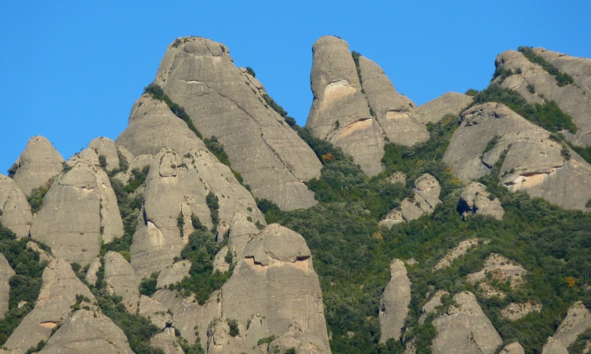
Gorra Frígia and Magdalena Superior, south-west faces, Montserrat

Spain · Montserrat

Via del Carles

A straightforward line up the 'Phrygian cap' visible from the monastery. Only the short vertical step on pitch 3 is sustained. It is a good route for learning Montserrat pebble technique and has a summit cross with a big view. The approach takes about 10 min from the Sant Joan funicular top.

5c5 pitches140 m

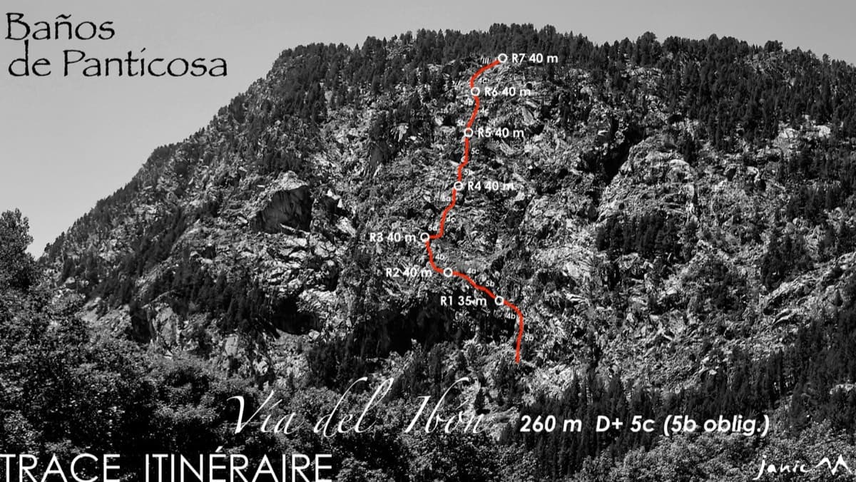
The Pared del Ibón above Baños de Panticosa with the line and belays of Vía del Ibón

Spain · Aragonese Pyrenees (Tena & Canfranc valleys)

Vía del Ibón

A mountain-style line on dark, weathered granite twenty-five minutes above the spa of Baños de Panticosa. It links ramps, a short overhanging break, slabs and a rounded boulder, with one well-bolted 5c move and the rest 4b to 5b. The rock between the good sections is earthy and lichenous, but the friction is excellent and the bolting generous.

5c7 pitches260 m

Compiled from published sources and last verified October 2026. Bolts, anchors and access change. Climbing is dangerous and you are responsible for your own decisions: check a current topo and read the disclaimer.