Multipitch Atlas

Arista Mowgli

Pared de Bozuelo, Baños de Panticosa · Aragonese Pyrenees (Tena & Canfranc valleys) · Spain

Easy to bailBolting confidence: high

An easy granite ridge above the Bozuelo meadows, low-angled and never exposed. Two smooth friction slabs at 5a, on pitches 1 and 6, are the only real difficulties; the rest is steps and short walls at grade 3 to 4. Ideal for a first multipitch, and you can step off rightwards onto ledges almost anywhere.

Line of the Arista Mowgli on the Pared de Bozuelo above Baños de Panticosa, with belays markedPhoto: janic · CC BY-SA 3.0

Topo

Line of the Arista Mowgli on the Pared de Bozuelo above Baños de Panticosa, with belays markedPhoto: janic · CC BY-SA 3.0
Hardest pitch
5a
Pitches
7
Length
200 m
Approach
40 min
Aspect
SE
South-east-facing
Rope
1×50 m
walk-off

The route

Overview

Seven short pitches up a low-angled granite ridge on the left of the Llanos de Bozuelo, on the way from Baños de Panticosa to the Bachimaña refuge. The difficulties are isolated: a smooth friction slab in the middle of pitch 1 and another at the start of pitch 6, both 5a and both well protected. Between them the ridge is stepped and easy. The opening team designed it as part of a way to climb, not walk, up to the Bachimaña refuge, linking the Vía del Nano, Espolón Rebollón, this ridge and the Espolón del Pino. It has 18 logged ascents on camptocamp and consistently good reviews.

The climbing

Pitch by pitch

Pitches of Arista Mowgli
PitchGradeLengthBoltsNotes
P15a30 m6 boltsA short wall of about 4 m with an awkward move, some 10 m of walking, then a smooth easy-angled slab with a thin friction move in the middle where you have to trust your feet. One writer suggests skipping the first little wall.
P24b30 m6 boltsSteps to a pine, which you use to get over the small roof above it (the 'pine move'). Then easy-angled steps to the belay.
P34a25 m4 boltsSteps, then a small slab after a pine. Belay at a pine.
P43a25 m3 boltsA small, easy-angled crest.
P53b25 m7 boltsSteps, left across an earthy gully, up a small slab, then a horizontal traverse left to the belay. One source gives 30 m.
P65a30 m6 boltsA fine smooth slab with friction moves at the start, very well protected, finishing up an unusual 'wrinkled' slab. Belay at a big pine, which is better for communication than the next belay 5 m further on (R6 bis).
P74c30 m4 boltsFrom R6 bis: a short vertical slab, easiest by its left edge, then an easy-angled friction slab with a small bulge and a last slab to the final belay at a pine.

Getting there

Approach

To the parking

Base is Baños de Panticosa (Balneario de Panticosa, about 1,640 m) at the head of the Tena valley. Park near the Casa de Piedra refuge; parties in 2024 report no trouble parking there.

On foot · about 40 min

35 to 45 min. Take the GR11 behind the Casa de Piedra refuge towards the Bachimaña refuge. After about 15 min you pass one of the Caldarés waterfalls; another climb brings you to the flat Llanos de Bozuelo. The ridge is clearly visible on the left. Follow cairns to its base, where a cairn marks the start.

Finding the route · 3 photos

Approach photo

Map of the walk-in

  • Crag
  • Parking
  • GPS line

Loading map

The point marks the crag, not the exact start of the route.

GPS line: one party's recorded GPS track of the whole day, including the climb and the descent. One party's recorded day in September 2024: walk-in from Baños de Panticosa (40 minutes), the climb, and the walk back down (40 minutes). Do not follow it blindly.

GPS line: oskarmorales · CC BY-NC-ND 3.0

Coordinates · crag

42.76969, -0.23146

Parking

42.75957, -0.23461

Baños de Panticosa (camptocamp access point)

Point from camptocamp waypoint 676807

For your phone or watch

Download GPX

Contains the route point, parking and a GPS line. Opens in most mapping apps and GPS watches.

Points are compiled from published sources, with the precision stated above. They were not surveyed on the ground: check them against a current topo.

Getting down

Descent

From the last belay follow the cairns to the right. A good path reaches the GR11 in about 10 min, above the Llanos de Bozuelo. Allow about 40 min back to the car park.

Retreat

Bailing off the route

Easy to bail

A Basque guide blog notes that you feel you could abandon the route at any moment by using the terraces and gullies on the right. The ridge is low-angled and never exposed, and the pitches are 25 to 30 m between bolted or tree belays.

Retreat from
Almost any belay, by walking or scrambling off right onto the ledges and gullies.
Point of no return
None.
Carry
Nothing special; a 50 m rope if you prefer to abseil a pitch (not described).
Basis
Stated in the sourcesThe Eskalatzencas description states the escape options; the detail of the ground on the right is not described further.

Safety

Hazards

  • The 5a friction slabs feel hard for the grade to people not used to granite: 'quite cheeky for 5a' in one 2023 report.
  • Some belays are on trees.
  • A July 2026 party noted fine weather turning stormy during the day; start early in summer.

Sun and weather

Conditions

South-east facing at 1,850 to 2,050 m. A summer route: reports run from early July to early October. Friction slabs, so wait for dry rock.

Usual season · Jun to Oct

Sun on the wall · SE-facing

Working out the sunlit hours for this month.

  • January: not yet worked out
  • February: not yet worked out
  • March: not yet worked out
  • April: not yet worked out
  • May: not yet worked out
  • June (usual season): not yet worked out
  • July (usual season): not yet worked out
  • August (usual season): not yet worked out
  • September (usual season): not yet worked out
  • October (usual season): not yet worked out
  • November: not yet worked out
  • December: not yet worked out

Sun on the wallDaylight, wall in shade● Usual season

Estimated from the wall's aspect only. Ignores surrounding terrain, gullies and the wall's exact shape. Clock times are local to the wall (Central European time), for the 15th of each month.

Climate figures for Aragonese Pyrenees (Tena & Canfranc valleys) are not available yet

What to carry

Gear

Camptocamp says a 50 m rope and 8 quickdraws plus belay gear, including two 60 cm slings to reduce drag. A Basque guide blog says 7 quickdraws; a 2023 party found 5 enough. Cams and nuts are not needed. Slings for the pine belays.

Checklist

Quickdraws
8
Rope
1×50 m (walk-off)
Helmet
One each

Derived from the route data; check it against a current topo

From climbers

Reader reports

Reader reports are not being collected yet. Until they are, check a current topo and the local club or guidebook publisher for recent changes to Arista Mowgli.

Worth knowing

Tips

  • Allow 1.5 to 2 hours; fast parties link it into two or three long pitches.
  • Climbed in approach shoes by confident parties.
  • Popular combinations: Vía del Nano and Espolón Rebollón first, or Lady Lister before and the Mur de la Cascade de Bachimaña after.
  • Make the belay at the big pine at the end of pitch 6 so you can hear each other.

Open questions

Where sources disagree

  • Name: spelled Mowgli, Mogli and Mogly in different sources.
  • Pitch lengths: camptocamp gives 25 m for pitch 5 and 30 m for pitch 6; the Eskalatzencas blog gives 30 m and 25 m.
  • Quickdraws: 8 (camptocamp), 7 (Eskalatzencas), 5 (a 2023 report).
  • Approach: 45 min (camptocamp), 35 to 40 min (Eskalatzencas), 30 to 40 min in reports.

Provenance

Sources

Same area

More in Aragonese Pyrenees (Tena & Canfranc valleys)

All routes in Aragonese Pyrenees (Tena & Canfranc valleys)
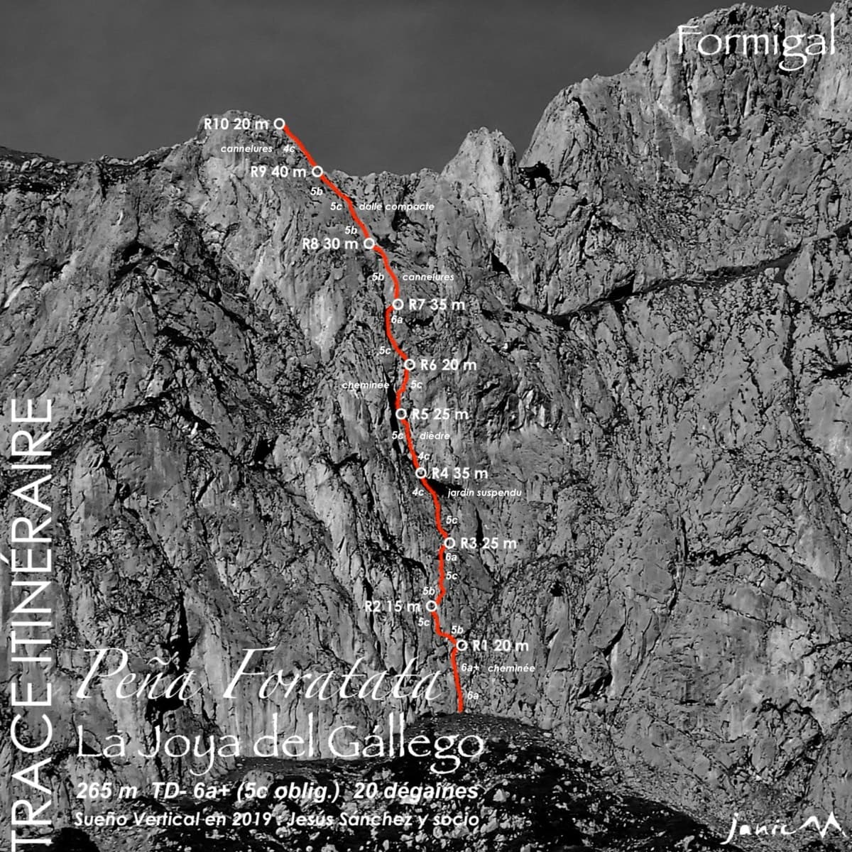
Topo of La Joya del Gállego on the Peña Foratata

Spain · Aragonese Pyrenees (Tena & Canfranc valleys)

La Joya del Gállego

Varied, sustained limestone of chimneys, dihedrals and compact fluted slabs high above the Tena valley. Bearded-vulture nesting closes the face from 1 Dec to 31 Jul unless lifted early, so check montanaregulada.org.

6a+10 pitches265 m

Read the cautions
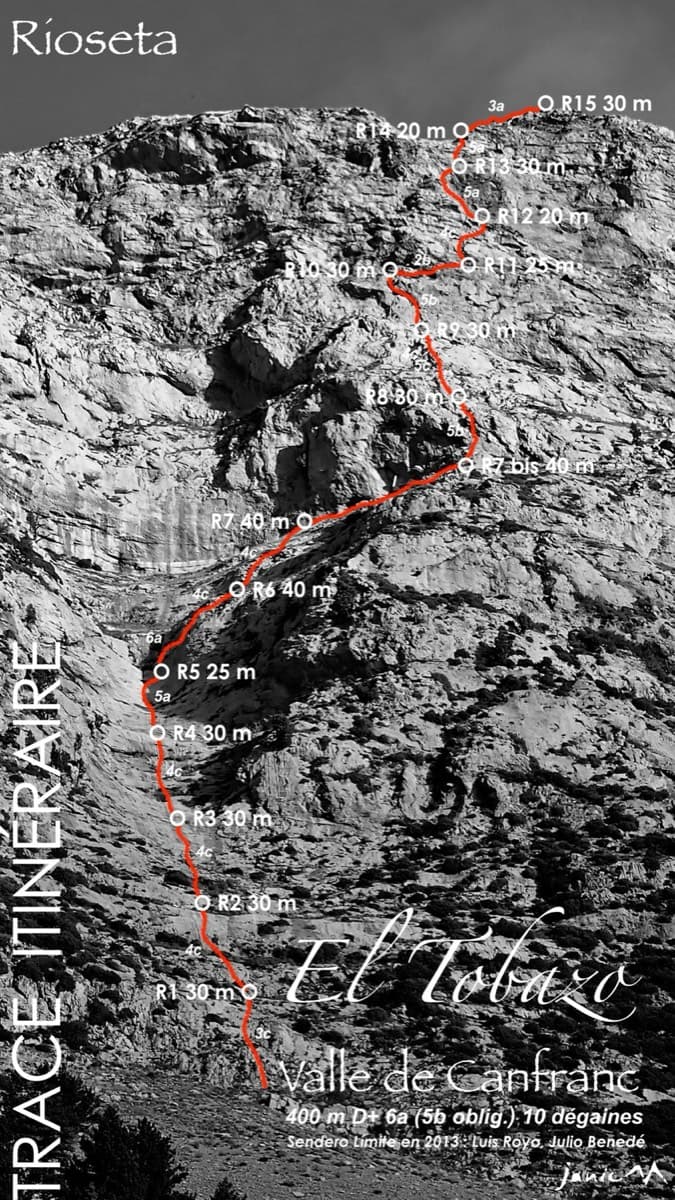
Topo of Valle de Canfranc on the south face of El Tobazo

Spain · Aragonese Pyrenees (Tena & Canfranc valleys)

Valle de Canfranc

A long, mostly easy slab-and-dihedral route with a single 6a slab on pitch 6, in a fine setting facing away from Candanchú. Wait about 30 h after rain because the lower gully drains water.

6a15 pitches400 m

Topo of Roca por un Tubo, Pared de la Tubería (Cerro Gascón), Baños de Panticosa

Spain · Aragonese Pyrenees (Tena & Canfranc valleys)

Roca por un Tubo

High-mountain granite slabs and dihedrals above the Panticosa spa. Three 6a cruxes mix friction slab with a short flaky roof on pitch 7.

6a9 pitches300 m

Read the cautions

The Pared del Ibón above Baños de Panticosa with the line and belays of Vía del Ibón

Spain · Aragonese Pyrenees (Tena & Canfranc valleys)

Vía del Ibón

A mountain-style line on dark, weathered granite twenty-five minutes above the spa of Baños de Panticosa. It links ramps, a short overhanging break, slabs and a rounded boulder, with one well-bolted 5c move and the rest 4b to 5b. The rock between the good sections is earthy and lichenous, but the friction is excellent and the bolting generous.

5c7 pitches260 m

Around 5a · about 7 pitches

Similar elsewhere

No photo yet

Switzerland · Wiwanni (Baltschiedertal)

Salamander

Eight short pitches of 4b to 5a on compact, grippy gneiss slabs above the Wiwannihütte, finishing on a 2880 m summit. Pitches 3 and 4 climb a big steep slab that is the heart of the route. Chained belays and an abseil descent make it the gentlest introduction to the Wiwanni routes, though the starting pitches feel stiff for 4b.

5a8 pitches180 m

The Schneekar and the north side of the Treffauer, where the route climbs the lower rocks beside the normal route

Austria · Wilder Kaiser

König der Löwen

Nine pitches of easy slabs and water runnels beside the Treffauer normal route, UIAA 5 at most if you take the easy variant on pitch 4. Lots of bolts and friendly ground make it one of the most popular routes in the Schneekar. The rock is not solid everywhere and the walk-in is two hours.

5a9 pitches280 m

The Röthelstein near Mixnitz

Austria · Grazer Bergland

Strauchdieb

A new (2025) nine-pitch outing on the right edge of the Breite Wand that weaves between the bushes. Three spots of UIAA 5-/5, otherwise easier. Still a little earthy in places.

5a9 pitches260 m

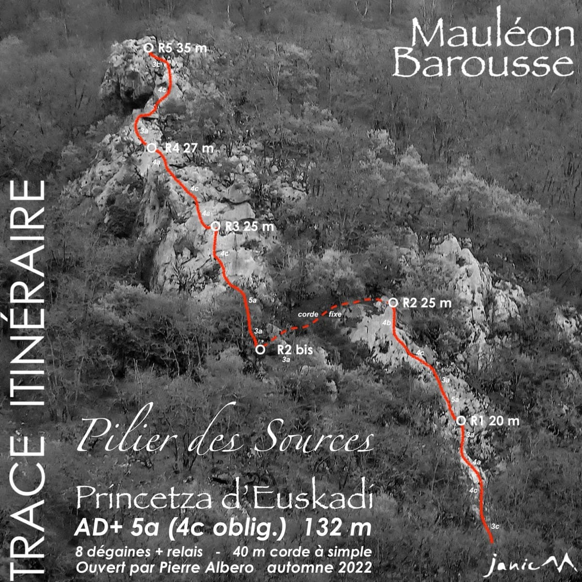
Photo-topo of Princetza d'Euskadi on the Pilier des Sources, Mauléon-Barousse, with belays and pitch lengths

France · Barousse (Central Pyrenees)

Princetza d'Euskadi

A short, friendly pillar of wonderfully rough, sculpted limestone above a Pyrenean village, bolted in 2022 as a first multipitch. Five pitches of grade 3 and 4 with single moves of 5a (4c obligatory), fifteen minutes from the car. Ideal for learning rope work; experienced parties move together and are up in an hour.

5a5 pitches132 m

Compiled from published sources and last verified October 2026. Bolts, anchors and access change. Climbing is dangerous and you are responsible for your own decisions: check a current topo and read the disclaimer.