Multipitch Atlas

L'île aux Razmokets

Vallon de Bérard (Vallorcine) · Chamonix valley · France

Easy to bailBolting confidence: high

A long, friendly slab route in the quiet Vallon de Bérard: twelve pitches that follow a chain of cracks and flakes across a compact gneiss slab, with two sustained 5c pitches low down. It stays in the shade until about midday, which makes it a summer route, and it dries slowly. Many parties stop after pitch 7 or 8 and abseil.

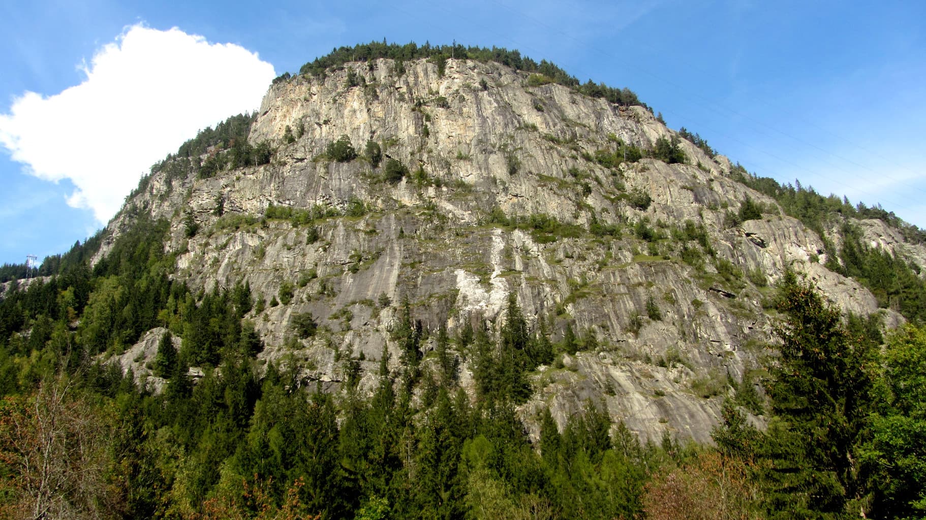
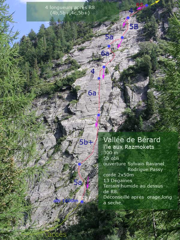
The slab of L'île aux Razmokets in the Vallon de Bérard, seen through the larches from the valley path; the line is not marked.Photo: Céline Stern-Kiener · CC BY-SA 3.0

Photo

The slab of L'île aux Razmokets in the Vallon de Bérard, seen through the larches from the valley path; the line is not marked.Photo: Céline Stern-Kiener · CC BY-SA 3.0
Hardest pitch
5c
Pitches
12
Length
350 m
Approach
50 min
Aspect
NW
North-west-facing
Rope
2×50 m

The route

Overview

L'île aux Razmokets climbs a big north-west-facing gneiss slab above the Bérard torrent, between Le Buet and the Pierre à Bérard hut. The line links fractures across otherwise blank rock: stepped chimneys, a long rising traverse on friction and side-pulls, flakes and easy slabs. The main wall is eight pitches; after a short walk four more pitches lead to the top. It is well bolted with comfortable belays, so it suits a first long route, as long as you are happy on 5c slab with traverses. The setting is green and damp, and the upper part is often wet.

The climbing

Pitch by pitch

Pitches of L'île aux Razmokets
PitchGradeNotes
P14bEasy stepped chimneys to reach a rock horn on the left.
P25cA long rising traverse along a system of cracks, with friction moves and side-pulls. Parties find it thin and the best pitch; it climbs hard for the grade when cold.
P35cStraight up, then a traverse right. Chipped holds just below the belay; without them the move is about 6a. A 2026 party notes you can avoid them by stepping a metre right at the same grade.
P44bEasy linking pitch.
P55b+Straight up, then step onto the slab on the left. Chipped holds again below the belay; a 2026 party passes a metre to the left at about 5c+. The English camptocamp text and the Thivierge topo grade this pitch 5c and 6a.
P64cEasy slab.
P75aA succession of flakes, very enjoyable. Camptocamp advises stopping here if the rock is not perfectly dry.
P84aEasy pitch to the top of the main wall. A September 2026 party found the friction slab damp and awkward. From the belay, walk left and then right along the foot of the next cliff; one party describes this transition as boggy.
P94cFirst pitch of the upper section.
P105bNo description published.
P114cNo description published.
P125bLast pitch.

Getting there

Approach

To the parking

From Chamonix drive over the Col des Montets towards Vallorcine. About 500 m before the hamlet of Le Buet, turn left onto a track and park, or park along the road or at Le Buet station (pay). The Mont-Blanc Express train (Saint-Gervais to Martigny) stops at Le Buet on request. The Col des Montets can be closed for avalanche risk outside summer.

On foot · about 50 min

Follow the track to the Cascade de Bérard, then the path up the valley on the true right bank of the torrent. Pass the bridge at the buvette and another small bridge that branches off, and continue to the newer bridge where the main path crosses to the left bank. Do not cross: stay on the right bank and take a faint path on the left that runs level through tall vegetation and then climbs to the foot of the slab. The English camptocamp text says the turn-off is marked by a rock with a red '16'. At the slab, ignore the first route you meet (its first bolt is near the ground and the rest are spaced) and go 15 m further right up an easy stepped ramp, right of a big slab, to a bolted crack-chimney. Allow 40 to 50 minutes.

Map of the walk-in

  • Crag
  • Parking

Loading map

The point marks the crag, not the exact start of the route.

Coordinates · crag

46.01222, 6.90028

Parking

46.01861, 6.91917

Le Buet (camptocamp waypoint 104355); roadside and station parking

Point from camptocamp waypoint 43205 (Vallon de Bérard)

For your phone or watch

Download GPX

Contains the route point and parking. Opens in most mapping apps and GPS watches.

Points are compiled from published sources, with the precision stated above. They were not surveyed on the ground: check them against a current topo.

Getting down

Descent

Abseil the route. On a single 50 m rope it takes 10 abseils. With 2×50 m you skip three belays: from R12 to R10, from R6 to R4 and from R2 to the ground (this last one can be split at an anchor right of the first-pitch chimney). The first and last abseils use the whole 50 m. A June 2026 party took an hour to abseil from R8.

Retreat

Bailing off the route

Easy to bail

Abseiling the route is the normal descent and every belay is two linked bolts, so you can turn round at any belay. Many parties plan to stop at R7 or R8. With a single 50 m rope you abseil pitch by pitch; pitches 2 and 3 traverse, so stay on the abseil line shown in the topo.

Retreat from
Any belay; R7 and R8 are the usual turning points.
Point of no return
None documented. After R8 you walk to the upper section, and you must come back the same way to abseil.
Carry
The rope you climb on: 2×50 m is quicker, and the first and last abseils need the full 50 m.
Basis
Stated in the sourcesCamptocamp describes the abseil descent in the route and the linked belays; several 2026 reports describe abseiling from R7 or R8.

Safety

Hazards

  • Slow to dry. If it is not completely dry, stop at the seventh belay; the upper slabs are wet more often than not.
  • The first and last abseils need a full 50 m. Knot the rope ends.
  • The first line of bolts you reach at the slab belongs to another, more spaced route. Start 15 m further right.
  • Pitches 2 and 3 are sustained traverses at 5c: the second needs to be as comfortable as the leader.
  • Popular in hot weather; expect other parties above and below on a shared abseil line.

Sun and weather

Conditions

North-west facing, with the base at about 1600 m according to the Thivierge topo. The slab is in shade until about 12:00 to 13:00 in summer, which is ideal in hot weather and chilly by late September (a party climbed in a down jacket on 27 September 2026). The area is damp and the rock dries slowly: avoid it after rain or storms. The ground above the eighth belay is often wet.

Usual season · Jun to Sep

Sun on the wall · NW-facing

Working out the sunlit hours for this month.

  • January: not yet worked out
  • February: not yet worked out
  • March: not yet worked out
  • April: not yet worked out
  • May: not yet worked out
  • June (usual season): not yet worked out
  • July (usual season): not yet worked out
  • August (usual season): not yet worked out
  • September (usual season): not yet worked out
  • October: not yet worked out
  • November: not yet worked out
  • December: not yet worked out

Sun on the wallDaylight, wall in shade● Usual season

Estimated from the wall's aspect only. Ignores surrounding terrain, gullies and the wall's exact shape. Clock times are local to the wall (Central European time), for the 15th of each month.

Monthly climate averages for Chamonix valley, 1991-2020
MeasureJanFebMarAprMayJun (usual season)Jul (usual season)Aug (usual season)Sep (usual season)OctNovDec
Mean daily high °C−4−31481315151281−4
Mean daily low °C−12−11−8−5−04663−1−7−11
Rain days 1 mm or more131213141919181715131414

● marks the usual climbing season. Averages for 1991-2020 at about 2011 m. Area climate from Open-Meteo reanalysis. Temperatures are adjusted to the height of the crag; rain comes from a grid cell of about 10 to 25 km, and summer highs on sea cliffs can read a few degrees low. The wall and valley can differ. Data: Open-Meteo, CC BY 4.0.

What to carry

Gear

13 quickdraws, 2×50 m ropes and a helmet. Nothing else is needed.

Checklist

Quickdraws
13
Rope
2×50 m
Helmet
One each
Abseil device and prusik
The descent or the retreat involves abseiling

Derived from the route data; check it against a current topo

From climbers

Reader reports

Reader reports are not being collected yet. Until they are, check a current topo and the local club or guidebook publisher for recent changes to L'île aux Razmokets.

Worth knowing

Tips

  • Parties report about 3 to 3.5 hours for the first eight pitches and an hour to abseil.
  • The main wall (pitches 1 to 8) is the best of the climbing; several recent parties stopped at R7 or R8.
  • A good choice for a heatwave day when the south-facing Aiguilles Rouges are too hot.

Open questions

Where sources disagree

  • Grades: the French camptocamp text gives pitch 5 as 5b+ with the chipped holds and 6a without; the English text gives 5c; the Thivierge photo-topo gives 5a, 5b+, 6a, 4, 6a, 5a, 5b, 4 for the first eight pitches and 4b, 5b+, 4c, 5b+ above. The French camptocamp grades are used.
  • Length: 350 m of difficulties on camptocamp, 300 m on the Thivierge topo.
  • Approach: 45 minutes (English text), 50 minutes (French text); recent parties took 40 to 50 minutes.
  • The camptocamp crag point carries an elevation of 1981 m, which is well above the foot of the route (about 1600 m on the Thivierge topo).

Provenance

Sources

Same area

More in Chamonix valley

All routes in Chamonix valley
The painted sign marking the start of the Voie Câline on the Rocher des Mottets

France · Chamonix valley

Voie Câline

Nineteen very short pitches of easy slab above Les Bois, never harder than 4b and bolted like a climbing school. It is the standard first multipitch of the Chamonix valley, long enough to feel like a real outing and finishing at a mountain café with a view of the Mer de Glace.

4b19 pitches260 m
The gneiss slabs of Les Chéserys beside the Lac Blanc path, with the pinnacle of the Aiguillette d'Argentière and the village of Argentière below; the Voie Jaune is on these slabs, its exact position is not marked.

France · Chamonix valley

Voie Jaune

A short, friendly slab route on the sunny gneiss of the Chéserys, facing the Mont Blanc range. Five pitches with one vertical step of 4c, chain belays and an abseil descent make it a standard introduction to multipitch climbing.

4c5 pitches150 m

The summit of Le Brévent and the rock face beneath its cable-car station, seen from the Chamonix valley; the Voie Frison-Roche climbs this south-east face, the exact line is not marked.

France · Chamonix valley

Voie Frison-Roche

The great classic of the Aiguilles Rouges: six varied pitches of gneiss, ten minutes downhill from the Brévent cable car and finishing at its top station, with Mont Blanc opposite. The crux is a short, physical corner crack and the last pitch is a long, clean corner. It is extremely popular.

6a+6 pitches200 m

The Barberine cliff above the spruce forest at Vallorcine; Méduse climbs this wall, the line is not marked.

France · Chamonix valley

Méduse

A direct line up the big south-facing slabs of Barberine: three pitches of friction slab to warm up, then steeper, technical walls on small holds. The two top pitches are graded 6b+ and 6c+ if you step round the bolts and 7a if you climb straight up them; 6c is obligatory.

7a7 pitches230 m

Around 5c · about 12 pitches

Similar elsewhere

The Palavar slabs above Ailefroide; Palavar-les-Flots follows the leaning pillar on the left

France · Ailefroide

Palavar-les-Flots

Ailefroide's best-known easy long route: a consistent run of 4th-grade slab and pillar climbing with two harder steps (5b+ on L4, a 5c friction move on L8). It is very popular, so start early.

5c12 pitches310 m

Annotated aerial view of El Chorro showing Frontales, Escalera Árabe and Escalera Suiza (labels in Polish)

Spain · El Chorro

Blue Line

The longest easy line in El Chorro. It starts up a broken corner-ramp, then climbs a steeper wall trending right to the top. It's uncommitting and easy to link pitches, with some loose rock to watch for.

5c12 pitches310 m

The east face of Pico de Anayet with the line and belays of Los Balcones de Anayet

Spain · Aragonese Pyrenees (Tena & Canfranc valleys)

Los Balcones de Anayet

A long, easy mountain route to a 2545 m summit above the Anayet lakes, on the dark volcanic rock of an old volcanic plug. Mostly 4c to 5a with one fine 5c corner on pitch 4; the lower half has broken rock and grassy channels, the upper 'balconies' are better. The day is long: two hours in, a via ferrata step on the approach and two hours out.

5c12 pitches350 m

Read the cautions

The narrows of the Todra Gorge in late afternoon light, a few minutes' walk upstream of the Mansour wall; a view of the gorge, not of this route's wall.

Morocco · Todra Gorge (Todgha)

Berbertraum

Thirteen short pitches, mostly grade 4, with two 5c steps. The longest pitch is 45 m. A big day of easy mileage in the sun above the palm grove.

5c13 pitches340 m

Compiled from published sources and last verified October 2026. Bolts, anchors and access change. Climbing is dangerous and you are responsible for your own decisions: check a current topo and read the disclaimer.