Multipitch Atlas

Douce Maye

Tête de la Maye – south face · La Bérarde (Écrins) · France

Bail with caveatsBolting confidence: high

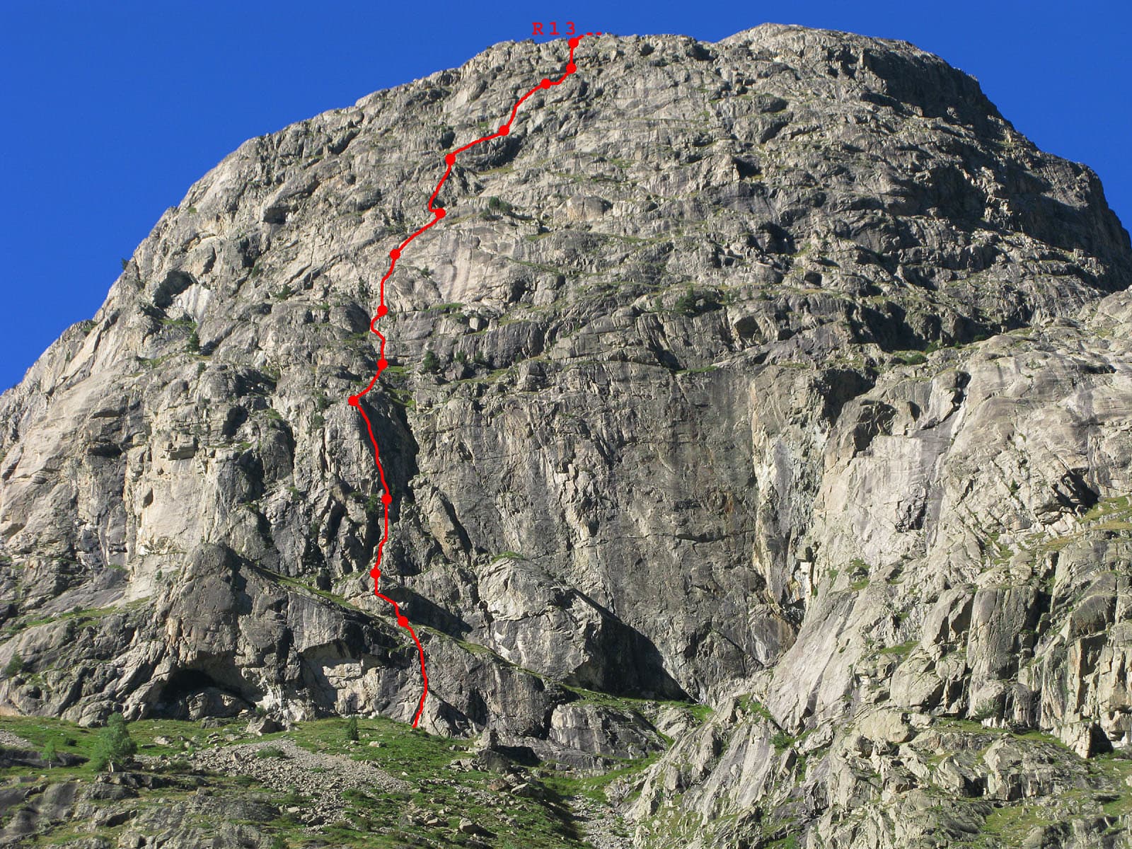
A long, gentle introduction to multipitch: about fifteen pitches of easy-angled granite slab and short cracked steps, almost all at 4b, with one 5b move. The hikers' path crosses the route, giving easy escapes after pitches 6, 7, 8 and 13. Sunny from early morning.

Topo photo of the Tête de la Maye; Douce Maye is line 18 on the right, crossing the hikers' pathPhoto: Michmuch38, Bruno Besson, L. Besson, Céline Stern-Kiener · CC BY-SA 3.0

Topo

Topo photo of the Tête de la Maye; Douce Maye is line 18 on the right, crossing the hikers' pathPhoto: Michmuch38, Bruno Besson, L. Besson, Céline Stern-Kiener · CC BY-SA 3.0
Hardest pitch
5b
Pitches
15
Length
400 m
Approach
45 min
Aspect
S
South-facing
Rope
1×50 m
walk-off

The route

Overview

Douce Maye is the rightmost bolted line on the south face and one of its two easiest long routes. It strings together short sections of sound, playful rock separated by grass ledges and walking, and the rock improves as you gain height. Since the 2022 rebolt it is used by clubs for teaching belays and rope management, and you can climb all or part of it thanks to the escapes onto the footpath. There is little sense of exposure; the reward is the view over La Bérarde and the upper Vénéon.

The climbing

Pitch by pitch

Pitches of Douce Maye
PitchGradeNotes
P14bA few steps, then a slightly grassy ramp rising right. Belay to be linked, on the right at the end of a diagonal ledge.
P24bA fine easy-angled slab.
P35bEasy flakes towards the bolt, then one harder move; belay on a terrace to the right.
P44bAfter this pitch traverse left for 30 to 40 m along a grassy ledge to find the continuation. The direct line above the belay is grassier and was not re-equipped.
P54bA diagonal crack, started on the right.
P63c/4aA grassy finish. Easy escape by the path.
P74bEasy escape by the path at the end.
P83bA step that can be turned on the left. The route crosses the footpath here: go straight up towards a bolt just above it.
P94bA pleasant curving gully of slab and crack.
P104b–
P112Easy ground.
P124bA crack leading left; ignore the bolt out to the right.
P133bEasy escape by the path at the end. The belays invite you to split this pitch in two.
P144cA flared crack.
P153bSlabs and some grass to finish.

Getting there

Approach

To the parking

La Bérarde is the last hamlet of the Vénéon valley, at the end of the D530 from Bourg d'Oisans (Grenoble side). A flood on 21 June 2024 wrecked much of the hamlet and swept away the car park in the riverbed, and road access has been restricted since. In summer 2025 the road was closed to general traffic beyond Saint-Christophe-en-Oisans, with shuttles from Bourg d'Oisans. In 2026 a June party found the road still closed with a shuttle promised for July; a party on 18 August took the first shuttle from Bourg d'Oisans at 06:20 and was in La Bérarde at 07:25; and a report dated 9 September 2026 says the hamlet can be reached by car again, with parking beside the reception chalet out of respect for residents. Check the current rules before you travel: the Maison du Département de l'Isère in Bourg d'Oisans (04 76 80 03 48) and the Saint-Christophe-en-Oisans town hall publish them. Do not count on the pre-flood shops and lodging; confirm what is open.

On foot · about 45 min

From La Bérarde start up the Châtelleret hut path and leave it leftwards at the 'falaise d'escalade' sign. A path contours west to below the start of Pujolidal, the spur that descends lowest, where a tricolour flag painted on a rock marks the national park boundary. A cairn on the right marks a track that rises rightwards along the cliff. Pass a zone of black overhangs to a small grassy cirque. At its lowest point on the right a faded white inscription marks the start; if in doubt it is the rightmost line of hangers on the cliff, with two close bolts visible. Camptocamp gives the start as 44.938 N, 6.29185 E. Allow 45 minutes.

Map of the walk-in

  • Route base
  • Parking

Loading map

The point marks the base of the route.

Coordinates · route base

44.93800, 6.29185

Parking

44.93268, 6.29186

La Bérarde road end and trailhead (camptocamp waypoint 106909). The riverbed car park was destroyed in 2024; check current access and where parking is allowed

Point from start coordinates stated in the camptocamp description of route 55818

For your phone or watch

Download GPX

Contains the route point and parking. Opens in most mapping apps and GPS watches.

Points are compiled from published sources, with the precision stated above. They were not surveyed on the ground: check them against a current topo.

Getting down

Descent

Go left to the Tête de la Maye footpath, which is equipped with cables on its steep sections and lower down joins the path from the Étançons valley. Camptocamp says 45 minutes; a 2023 party took 1 h 15, and adds 20 minutes if you first go up to the summit.

Retreat

Bailing off the route

Bail with caveats

You can leave the route on foot at four points: camptocamp lists easy escapes by the footpath at the end of pitches 6, 7, 8 and 13. Below pitch 6 there is no described retreat, and the belays are plain bolts without chains, so abseiling means leaving gear.

Retreat from
On foot after pitches 6, 7, 8 and 13.
Point of no return
None high on the route. On the first five pitches going up to the pitch 6 escape is likely simpler than descending (inferred).
Carry
Nothing special for the walk-offs. To abseil low down you would need maillons or karabiners to leave on unchained belays.
Basis
Part stated, part inferredThe walk-off escapes are stated by camptocamp and confirmed by a 2023 party who stopped after pitch 6; the comment on the lower pitches is inferred.

Partly inferred from the route facts

Safety

Hazards

  • Road access to La Bérarde has changed every season since the 2024 flood (closure, shuttles, reopening in September 2026). Confirm it before leaving.
  • Heat and sun exposure: full south, and a September 2026 party still needed sun cream.
  • Walkers use the footpath that the route crosses; do not dislodge stones from the ledges.
  • Route-finding at the 30 to 40 m leftward traverse after pitch 4, and at pitch 12 where a stray bolt tempts you right.

Sun and weather

Conditions

Full south-facing granite between about 1,900 and 2,500 m. Camptocamp gives May to October depending on snow, and warns that it is very hot in midsummer; the wall takes the sun early. Slabs with drainage streaks can stay wet after rain. This is a mountain setting: watch for afternoon storms, and note a June 2026 report of no phone signal on the face. A September 2023 party found pitches 1, 2 and 5 still damp at midday after morning rain, though the bolts are close enough to pull through.

Usual season · Jun to Sep

Sun on the wall · S-facing

Working out the sunlit hours for this month.

  • January: not yet worked out
  • February: not yet worked out
  • March: not yet worked out
  • April: not yet worked out
  • May: not yet worked out
  • June (usual season): not yet worked out
  • July (usual season): not yet worked out
  • August (usual season): not yet worked out
  • September (usual season): not yet worked out
  • October: not yet worked out
  • November: not yet worked out
  • December: not yet worked out

Sun on the wallDaylight, wall in shade● Usual season

Estimated from the wall's aspect only. Ignores surrounding terrain, gullies and the wall's exact shape. Clock times are local to the wall (Central European time), for the 15th of each month.

Climate figures for La Bérarde (Écrins) are not available yet

What to carry

Gear

12 quickdraws. Slings and karabiners to build every belay, since none is chained. A single 50 m rope; the descent is on foot. Helmet.

Checklist

Quickdraws
12
Rope
1×50 m (walk-off)
Helmet
One each
Maillons or spare karabiners
To leave behind if you retreat

Derived from the route data; check it against a current topo

From climbers

Reader reports

Reader reports are not being collected yet. Until they are, check a current topo and the local club or guidebook publisher for recent changes to Douce Maye.

Worth knowing

Tips

  • A group in September 2026 started above pitch 8, where the path crosses, for a shorter day.
  • Reported times: 5 h 30 for the whole route including lunch; 2 hours for the first six pitches.
  • The 2022 Cambon topo is more accurate than the camptocamp pitch list since the rebolt (see discrepancies).

Open questions

Where sources disagree

  • Pitch count: camptocamp lists 15 pitches (used here). An August 2023 party says the 2022 Cambon topo is more accurate, with 16 climbing pitches (17 if pitch 13 is split) plus 4 linking sections.
  • Grades: a September 2026 group found them closer to the printed topo than to camptocamp, without saying which pitches differ.
  • Aspect: camptocamp says south; one trip report says south-east. Descent time: 45 minutes on camptocamp, 1 h 15 in a 2023 report.
  • The camptocamp remarks still carry a pre-rebolt note that bolt spacing is below modern standards; post-2022 reports describe close, excellent protection.

Provenance

Sources

Same area

More in La Bérarde (Écrins)

All routes in La Bérarde (Écrins)
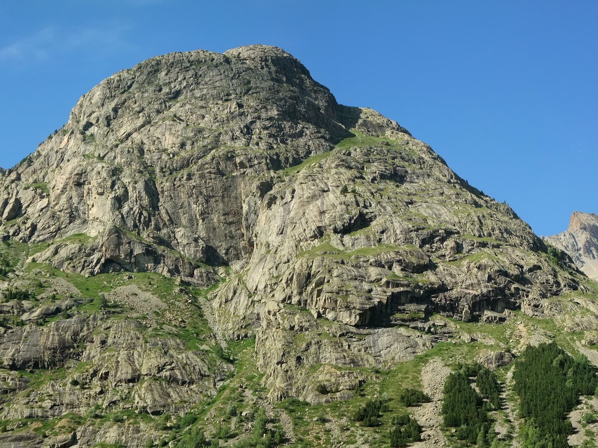
The granite slabs of the south face of the Tête de la Maye above the larches of La Bérarde; Pujolidal climbs this face, the exact line is not marked.

France · La Bérarde (Écrins)

Pujolidal

The great classic of the Tête de la Maye: 13 pitches of rounded granite slab above La Bérarde with nothing athletic until the last hard pitch, a flake and wide crack of 5c+ that everyone remembers. Recently rebolted and very closely protected. It is camptocamp's reference route for the overall grade D.

5c+13 pitches350 m
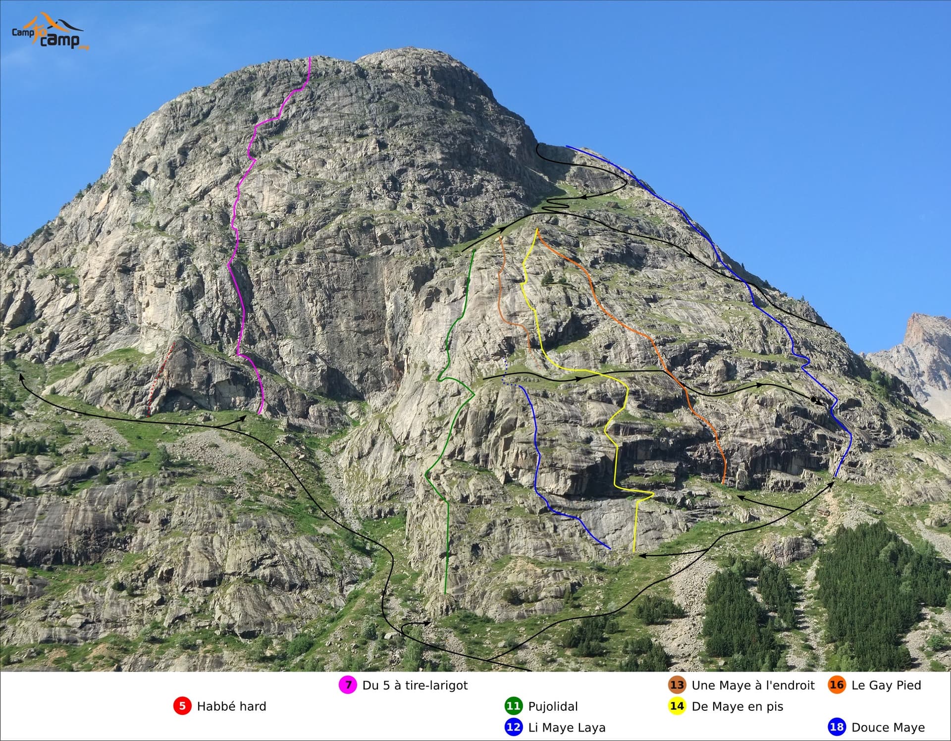
South face of the Tête de la Maye with route lines: Gay Pied is the orange line (16), Douce Maye the blue line on the right (18)

France · La Bérarde (Écrins)

Gay Pied

One of the easiest long routes on the Tête de la Maye: thirteen short pitches of low-angle granite slab, mostly grade 3 to 4, broken by a few steeper steps. The exception is the first pitch, a steep 5a/5b wall that is clearly the hardest and best climbing on the route.

5b13 pitches300 m

Du V à tire-larigot marked in red on the south face of the Tête de la Maye

France · La Bérarde (Écrins)

Du V à tire-larigot

The longest route on the Tête de la Maye at this grade and by far the most popular: fourteen pitches, sustained at 5b with three pitches of 5c. Steep steps, slabs, a roof, a layback crack on a pillar and a few grass ledges. The fives feel honest and only one 5b move is obligatory.

5c14 pitches400 m

The south face of the Tête de la Maye above La Bérarde

France · La Bérarde (Écrins)

Maye Friend

Fifteen pitches up the steeper centre of the face: steep cracks and walls in the first third, then a long sequence of sometimes very thin friction slabs. Mostly 5c to 6a+ with one short 6b+ that goes at A0. Rated among the best on the wall and much quieter than its famous neighbour.

6b+15 pitches400 m

Around 5b · about 15 pitches

Similar elsewhere

Alpe Gorta above Crevoladossola, with the rocky outcrops behind the huts

Italy · Val d'Ossola

Il Solitaire

A long, sunny friction-slab route of about 35 m pitches on excellent rock, ideal for learning footwork. The hardest move is a short crack-and-chimney finish on the last pitch. Allow about 3 h up and 1 h down.

5b13 pitches430 m

The Wiwannihorn from near the hut; the east ridge is the right-hand skyline

Switzerland · Wiwanni (Baltschiedertal)

Ostgrat (East Ridge)

A 17-pitch bolted ridge to a 3001 m summit. Three slab and wall pitches of 5a and 5b come first, then a long run of grade 3 and 4 on the crest that many parties climb moving together, with one fine 5a in the middle. A full mountain day: the summit ridge beyond the last bolt and the scrambling descent are part of it.

5b17 pitches400 m

Read the cautions

The east face of the Pic de l'Aiguille with two dotted route lines drawn by Serge Luby, one of the equippers. Camptocamp attaches the picture to both À l'aise Gleize and La Barule des Barulots without saying which colour is which.

France · Dévoluy

À l'aise Gleize

Twelve pitches of easy slab on water-worn runnels up the east face of the Pic de l'Aiguille, above Gap, finishing on a summit at 2140 m. Never harder than 5b and mostly 5a, but long: allow four to five hours. The bolts are well placed and spaced, the rock is very grippy, and stonefall from the ledges and from walkers on the summit is the main thing to watch.

5b12 pitches300 m

Read the cautions

Mont Chétif seen from Courmayeur in the morning: the route climbs the sunlit face below the summit

Italy · Aosta Valley

Alisée e gli Amici Canterini

The easiest route on the big east face of Mont Chétif, the rocky pyramid that stands over Courmayeur. Twelve short pitches of well-featured rock, mostly 4b, lead to a steep little corner on pitch 10 that is the one hard passage. You finish a few minutes below a summit with one of the great views of the south side of Mont Blanc.

5b12 pitches250 m

Read the cautions

Compiled from published sources and last verified October 2026. Bolts, anchors and access change. Climbing is dangerous and you are responsible for your own decisions: check a current topo and read the disclaimer.